


 Your new post is loading...

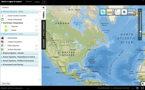

National Geographic Education beta has a new tool, MapMaker Interactive, that allows you to explore your world with maps. Select the region you want to map. There are options for themes, data and tools that allow for customization. Themes include Physical Systems: Water, Land and Climate; Human Systems: Population & Culture and Political and Economic; and Environment and Society. There are drawing tools and markers and you may download maps that you create. There is also a version that is black and white that has basic map elements as well as borders and names and other features. These maps may be printed out. The link to this is http://education.nationalgeographic.com/education/mapping/outline-map/?map=USA&ar_a=1. 
Via Beth Dichter


Great tool for World History and U.S. History classrooms.