


 Your new post is loading...

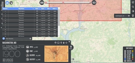

The USGS is on a open-access roll with topoView, an advanced new map-finding tool.
The cartography arm of the U.S. Geological Survey has been on an open-access roll. First they send their constantly updating stream of satellite imagery to what's basically a public dropbox, so that anyone can use Landsat-8 photographs for free. And now they're introducing topoView, an online archival tool that makes truly accessible the agency's 178,000 topographical maps, dating from 1880 (shortly after the USGS started mapping the country) to 2010.
Via Lauren Moss


aggiungi la tua intuizione ...