


 Your new post is loading...

|
Scooped by Jim Lerman |


Ruth Reynolds's curator insight,
December 3, 2016 9:33 PM
Just getting familiar with ArcGis and lots of ideas picked up at #ncss16

Olivia Campanella's curator insight,
September 5, 2018 4:09 PM
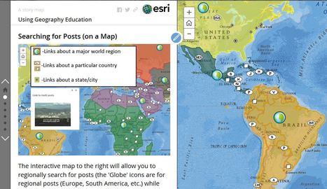
This map is a very helpful, useful and fun guide on how to get the most of this website and to learn about geography and different places and facts of the world.

Dominic Mappas's curator insight,
June 5, 2019 6:41 AM
This source allows its viewers to select countries to direct them to a series of topic links. This allows the audience to interact and explore the world through visual representation of the globe. I can see this being implemented for warm up activities, quizzes and practice questions. Great source!
Sign up to comment


