


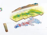

Encyclopedic entry. A geographic information system (GIS) is a computer system for capturing, storing, checking, and displaying data related to positions on Earth’s surface. GIS can show many different kinds of data on one map.
This informative webpage (and accompanying features) simply answer the question, "What is GIS and how is it a useful way to work with spatial data?"


 Your new post is loading...


Què és un sistema d'infromació geogràfica (SIG/GIS)?