Interesting links and articles related to IELTS, ESP, EAP and E-learning. Available to teach ESP, EAP, Research Skills, IELTS, TOEFL and General English.
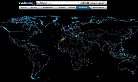
The Brazilian government's geographic department (Instituto Brasileiro de Geografia e Estatística-roughly equivalent to the U.S. Census Bureau) has compiled an fantastic interactive world factbook (available in English and Spanish as well as Portuguese). The ease of navigation allows the user to conduct a specific search of simply explore demographic, economic, environmental and development data on any country in the world.
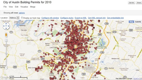
"Google Fusion Tables is an excellent way to create and share visualizations of data in map, chart, and tabular formats. Today we’re starting a new series of blog posts designed to get you up to speed with using this fantastic platform. We’ll also be releasing a free e-learning course called Bringing Data to Life with Google Fusion Tables to all our newsletter subscribers."
This is a video introduction to www.historypin.com which might just prove to be a very useful and important project. It's historical geography powered by collaborative mapping that is infused with social media dynamics. Backed by Google, they are geo-tagging old photos to recreate the historical geographies of all places and comparing them with current street view images. You can search by topic, place or date...this has the potential to be very big.
A free Resource for Teachers who use Google Earth. Providing everything from lesson ideas to complete lesson plans for both single computer classrooms to full computer labs.
If you were thinking about using Google Earth, but not sure how to get started, consider this your starting point. You will find tutorials, sample data sets, lesson plans, etc. Very well put together and incredibly helpful.
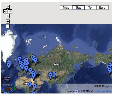
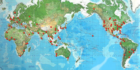
This Google Map is database for some highly educational virtual tours that can be used in social science classrooms. Included are 60 markers which represent more than 60 webcams and virtual tours. This list of 'online field trips' becomes a powerful way to open up the world to your students. Sample locations: Pryamid at Giza, Yellowstone Nat'l Park, Stonehenge, Great Barrier Reef and many more.
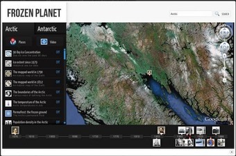
Very cool way to explore the colder realms of our planet. This web-based "Google Earth-like" resource comes preloaded with layers (ice extent, temperature, permafrost, biogeography, etc.) that would make for a great interactive lesson for many grade levels.
"The World Bank eAtlas of Global Development maps and graphs more than 175 thematically organized indicators for over 200 countries, letting you visualize and compare progress on the most important development challenges facing our world. Most indicators cover several decades, so you can see, for example, how 'life expectancy at birth' has improved from 1960 up through the latest year." This tool should greatly enhance student projects as they will add more data, and see bigger patterns. To go to the link visit: http://www.app.collinsindicate.com/worldbankatlas-global/en
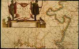
"The AFRITERRA Foundation is a non-profit Cartographic Library and Archive assembling and preserving the original rare maps of Africa in a definitive place for education and interpretation. This unique cartographic galleries links art, technology, and history." The Afriterra Foundation connects people to the land, history, heritage and legacy of Africa.
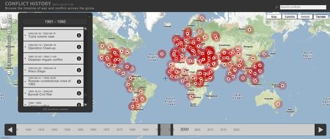
Browse the timeline of war and conflict across the globe.
This database of global wars and conflicts is searchable through space and time. You can drag and click both the map and timeline to locate particular battles and wars, and then read more information about that conflict. This resource would be a great one to show students and let them explore to find what they see as interesting. This site is brimming with potential.
the potential of this site is amazing between the interactive learning system and the correlation between the timeline and location. If the human geography class is anything like this i can't wait for it!
See photos from 7 Billion: http://bit.ly/hhYz3m With the worldwide population expected to exceed seven billion in 2011, National Geographic magazine offers a...
This video provides excellent material for discussing population growth, space and sustainability.
The increase in global population is definitely a hot button topic in today's world. Many wonder if the planet will be able to really sustain so many new people, and if it can truly sustain our current number of humans. This video does a good job of addressing these problems and presenting how things will likely come to be. Our planet is capable of producing great amounts of food and material the real hurdle comes down to how well nations will cooperate. Unfortunately politics and money seem to be the real snagging point in the distribution of aid and resources to many.
The rapid growth occurring is staggering. I believe we do need to start thinking about the future in generations. Where will we be in 50-100 years and where do we need to be. So basically you need to start thinking about your childrens' childrens' future. We need to make changes to sustain the increase in population.
"3 guys, 44 days, 11 countries, 18 flights, 38 thousand miles, an exploding volcano, 2 cameras and almost a terabyte of footage."
This video beautifully encapsulates the spirit of a globalized educational experience and the value of geographic understanding in an ever-interconnected world. Geography is about broadening our minds to other places, other cultures and other ways of doing things. In a three part series including 'Eat' and 'Move.'
This is great because it shows people are round the world what great people and cultures are available for people to explore. It also shows that great spirit that people are exposed to. It also shows that people are outgoing and do not let nothing bring them down.
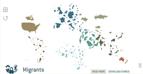
Learn about the world by changing the familiar map. Select a subject from the top menu and watch the map resize. A countrys total area no longer represents land mass, but items relevant to the subject (i.e.
The geovisualization in this interactive map is outstanding (translation: I could play with this all day). This displayed map shows the destination countries for migrants, with links to the data and information to read up on the topic. Truly impressive. For the live link, see: http://show.mappingworlds.com//world/?lang=EN
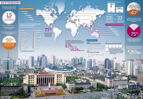
The rapid increase in the number of cities home to more than 10 million people will bring huge challenges … and opportunities...
It's not just that more people now live in cities than in the rural countryside (for the first time in human history). It's not just that major cities are growing increasingly more important to the global economy. The rise of the megacities (cities over 10 million inhabitants) is a startling new phenomenon that really is something we've only seen in the last 50 years or so with the expectation that the number of megacities will double in the next 10 to 20 years (currently there are 23). This reorganization of population entails wholesale restructuring of the economic, environmental, cultural and political networks. The urban challenges that we face today are only going to become increasingly important in the future.
More and more people are moving to the cities than ever before. As a result I believe there are more megacities on the way. However I think there is a limit to these cities. How are they going to be powered? How are the people going to be fed? Where will they work? how will these cities impact the environment? Where is all the fresh water going to come from?
It is a good thing that there is more megacities being created because you can see more people move in which will help the city function better economics wise. When it comes down to the population that is a different story because there is more people to worry and deal with. The increase of people could go both ways because it can be good but at the same time it can go bad because people will start arguing in which it can get physical which means city ratings going down.
Digital tools have faciliated an easier way to visually represent complex data and information in ways at are logical and intuitive. This blog post outlines tools that students can use (read: free!) along with basic tutorials to demonstrate their functionalities.
This provies the basic overview of the layout and function of http://geteach.com . The video unlocks some great features that are not intended to be hidden, but many first time visitors tend to miss.
This is a phenomenal site, designed by an AP teacher to bring geospatial technologies into the classroom in a way that is incredibly user-friendly. This site allows you to use Google Earth with clickable layers. With multiple data layers of physical and human geography variables, this interactive globe puts spatial information in powerful, yet fun, student-inspired platform.
I’ve added a two new drop-down menu tabs to this website for my geography education resources; one that is organized thematically (this one) and well as another that is regionally focused. T...
I’ve recently overhauled my other website http://geographyeducation.org in ways that will hopefully help teachers find specific resources for any given unit during the school year. I love this Scoop.it site for showing the latest materials that I’ve found. The “filter” function will also a teacher to search a specific topic as I’ve generated numerous “tags” to organize my posts. Still, if a teacher is searching for specific materials in a lesson on particular unit, there are many applicable “tags,” but they are arranged alphabetically. So I’ve added a drop-down tab entitled “thematic.” Under this drop-down menu are pages dedicated to all the units of AP Human Geography (and environmental and physical geography as well) with links for the pertinent sub themes organized by the AP Human Geography course outline. Additionally, I’ve included approximately 10 of my favorite resources for each unit to the corresponding page. I’ve also added a post slider where I’ll organize the most important posts of the last few weeks. Best of luck in the new school year!
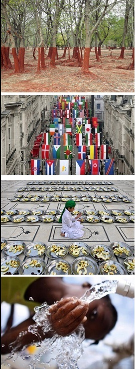
This is the truly global project that asks the children of the world to introduce us to the people of the world. We've seen videos and resources that ask the question, "if there were only 100 people in the world, what would it look like?" This takes that idea of making demographic statistics more meaningful one step further by asking student in schools for around the world to nominate some "representative people" and share their stories. The site houses videos, galleries from each continent and analyze themes that all societies must deal with. This site that looks at the people and places on out planet to promote greater appreciation of cultural diversity and understanding is a great find.
To get content containing either thought or leadership enter:
To get content containing both thought and leadership enter:
To get content containing the expression thought leadership enter:
You can enter several keywords and you can refine them whenever you want. Our suggestion engine uses more signals but entering a few keywords here will rapidly give you great content to curate.


 Your new post is loading...