IELTS, ESP, EAP and CALL
18.4K views | +0 today
Follow
IELTS, ESP, EAP and CALL
Interesting links and articles related to IELTS, ESP, EAP and E-learning.  Available to teach ESP, EAP, Research Skills, IELTS, TOEFL and General English.
Curated by Dot MacKenzie
Your new post is loading...
Rescooped by Dot MacKenzie from HumanGeo@Parrish
Scoop.it!

Russians are leaving the country in droves

Russians are leaving the country in droves | IELTS, ESP, EAP and CALL | Scoop.it
Over a bottle of vodka and a traditional Russian salad of pickles, sausage and potatoes tossed in mayonnaise, a group of friends raised their glasses and wished Igor Irtenyev and his family a happy journey to Israel.


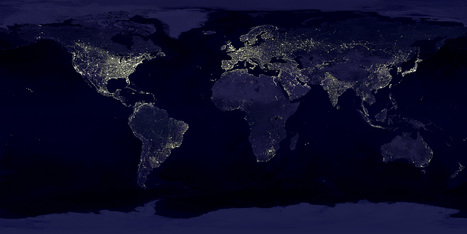
My regional class has been learning about Russia this week and when I first started teaching a few years ago, I would teach that Russia had a population of 145 million.  Today it is 141 million and part of that is due to migrants leaving a country that they see as lacking in economic opportunities and political freedoms (another part of the story is that birth rates plummeted after the collapse of the Soviet Union in what demographers have called the "Russian Cross").  In the last few years the population appears to have stabilized, but there are still many who do not see a vibrant future from themselves within Russia.  


Tags: Russia, migration, Demographics, immigration, unit 2 population.


Via Nathan Parrish
Meagan Harpin's curator insight, September 28, 2013 11:44 PM

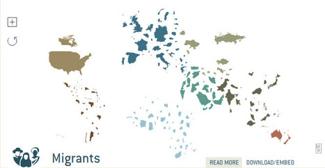
In the last 10 years about 1.25 million russians have emigrated out of Russia, but the way they do it is interesting. When they leave they dont sell their houses, or aparments, or cars they simply lock their doors and quietly slip away to the airports at night. The reasons for leaving are different thought, some are leaving because the prime minister is expected to return while some are leaving because of the awful econonmy. Either way the massive amounts of emigration is leading to a higher death rate then birth rate overall. 

Nathan Chasse's curator insight, March 1, 2014 1:23 AM

This article from a couple years ago is about Russian emigration. A large number of Russians were leaving the country for better economic opportunity. Some cite the overbearing rule of Putin, but the pay in other countries is just better than what Russia can offer. This was particularly the case for the more educated, another instance of "brain drain" hurting a nation which is already in trouble.

Jess Deady's curator insight, May 1, 2014 12:00 PM

Migration occurs for many reasons. People move from country to country every day. Leaving Russia was this families choice and moving to Israel can have an impact on them greater than if they were to stay in Russia.

Scooped by Dot MacKenzie
Scoop.it!

English Pronunciation

English Pronunciation | IELTS, ESP, EAP and CALL | Scoop.it

"If you can pronounce correctly every word in this poem, you will be speaking English better than 90% of the native English speakers in the world.

After trying the verses, a Frenchman said he’d prefer six months of hard labour to reading six lines aloud."


This is the darndest poem and shows how truly complex English pronounciation really is (while also showing how spatially contingent the very idea of 'correct pronunciation' actually can be). 

No comment yet.
Scooped by Dot MacKenzie
Scoop.it!

21 Regionally Distinct Accents

No comment yet.
Scooped by Dot MacKenzie
Scoop.it!

The World is all about Money

The World is all about Money | IELTS, ESP, EAP and CALL | Scoop.it

"A world map used by Erik Penser Bankaktiebolag to visualize economic markets. The map contains approximately 3,000 coins and every continent is built out of its countries’ currencies. Used in various medias during 2009."  If you look closely you will notice that the coins are from the region that they are cartographically representing.  To see more by this artist, visit: http://www.penser.se/

No comment yet.
Scooped by Dot MacKenzie
Scoop.it!

Earth's City Lights

Earth's City Lights | IELTS, ESP, EAP and CALL | Scoop.it
NASA's Visible Earth catalog of NASA images and animations of our home planet...


This classic image is full of classroom applications.  The first impulse of most students is to note that this image will show us where people live, where the cities are or some other comment that speaks to the magnitude of the population in the white areas.  Let them analyze this for more time, and they'll notice that population isn't the whole story of this image.  A place like India shines, but less brightly than the eastern part of the United States.  I like to point out that South Korea appears to be an island (because North Korea is literally blacked out).  Politics, development, affluence and population information are all embedded in this image.  As with all maps, the more information you have about the place in question (in this case, Earth), the more meaningful information you can extract out of the map. 


Tags: remote sensing, worldwide, consumption, poverty, population, spatial, political, regions.

No comment yet.
Scooped by Dot MacKenzie
Scoop.it!

Global data geovisualized

Global data geovisualized | IELTS, ESP, EAP and CALL | Scoop.it
Learn about the world by changing the familiar map. Select a subject from the top menu and watch the map resize. A countrys total area no longer represents land mass, but items relevant to the subject (i.e.


The geovisualization in this interactive map is outstanding (translation: I could play with this all day).  This displayed map shows the destination countries for migrants, with links to the data and information to read up on the topic.  Truly impressive.   For the live link, see: http://show.mappingworlds.com//world/?lang=EN

No comment yet.
Scooped by Dot MacKenzie
Scoop.it!

Where Is Europe?

Where Is Europe? | IELTS, ESP, EAP and CALL | Scoop.it
As both a concept and a continent, the area known as Europe has shifted over time.


Many see Europe (as a physical landmass) as not a discrete continent, but a peninsula on the Eurasian landmass.  Culturally though, the idea of Europe as distinctly bracketed of from Asia, is a powerful idea is not in the Western World.  Where is Europe?  What is Europe?  This article would provide good information for a lesson on regions and how we conceptualize the world within that regional framework. 

Cam E's curator insight, February 27, 2014 10:59 AM

Europe has never been a static concept, it's likely that even people who live in the same town as you have a different idea of what constitutes the far borders of Europe. Personally I like to make a distinction between types of Europe. It seems to me that what was traditionally Northern and Western Europe differ from Southern and Eastern Europe in a wide variety of ways, especially due to Southern Europe's proximity to Africa and the Middle East.


Scooped by Dot MacKenzie
Scoop.it!

European Maps: Ethnolinguistics

European Maps: Ethnolinguistics | IELTS, ESP, EAP and CALL | Scoop.it

This site houses several good maps, especially this one of the 'core' and 'periphery' of Europe. This map corresponds with maps that show the first places to be industrialized. The map on the formal culture regions is also useful for understanding cultural barriers to diffusion.  What's the connection between the branches of Christianity and Indo-European language families?  

Jacob Crowell's curator insight, December 8, 2014 11:36 AM

These maps are interesting. I find it striking how discriminatory some of these maps can be to some of the "periphery" populations using terms like savage. That comes from a map made in 1923, so it does seem to fit the time it was made in.

Scooped by Dot MacKenzie
Scoop.it!

AFRITERRA: Mapping Africa

AFRITERRA: Mapping Africa | IELTS, ESP, EAP and CALL | Scoop.it

"The AFRITERRA Foundation is a non-profit Cartographic Library and Archive assembling and preserving the original rare maps of Africa in a definitive place for education and interpretation.  This unique cartographic galleries links art, technology, and history."  The Afriterra Foundation connects people to the land, history, heritage and legacy of Africa.

No comment yet.
Scooped by Dot MacKenzie
Scoop.it!

The Real World at Night

The Real World at Night | IELTS, ESP, EAP and CALL | Scoop.it

Earlier I have posted the classic image of "Earth Lights at Night," and discussed the classroom uses of the image.  This cartogram helps take that analysis one step further.  This cartogram helps students to visualize the magnitude of population (with the cartogram adjusting area for population) and then to see the patterns of energy use, global consumption and urbanization with in a new light. 


Tags: remote sensing, worldwide, consumption, poverty, population, spatial, political, regions.

No comment yet.