


In this age of fast travel and instant digital communications, we tend to forget that not so long ago, distances were subjectively very different.
Get Started for FREE
Sign up with Facebook Sign up with X
I don't have a Facebook or a X account


 Your new post is loading...
 Your new post is loading...
Your new post is loading...
In this age of fast travel and instant digital communications, we tend to forget that not so long ago, distances were subjectively very different. 
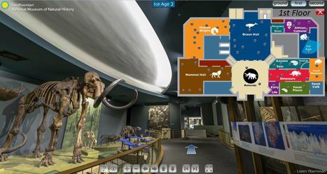
The Smithsonian Museum of Natural History is a fabulous resource in Washington D.C., but now this museum available virtually. Teachers can now bring the museums to the classroom with these fantastic Smithsonian virtual tours.
Tags: biogeography, virtual tours, environment, ecology, historical, physical.
This is a video introduction to www.historypin.com which might just prove to be a very useful and important project. It's historical geography powered by collaborative mapping that is infused with social media dynamics. Backed by Google, they are geo-tagging old photos to recreate the historical geographies of all places and comparing them with current street view images. You can search by topic, place or date...this has the potential to be very big.
Resources from Rhode Island College History and Social Studies educators for the classroom...
I'm branching out...mainly because I will be teaching an education methods course for History/Social Studies educators at Rhode Island College this coming semester. However, in the interest of making educational resources more communal, and creating collaborative networks, this site for archiving great history/social studies education resources (primarily for my students) will be publicly accessible and I hope that others might benefit from using these resources.
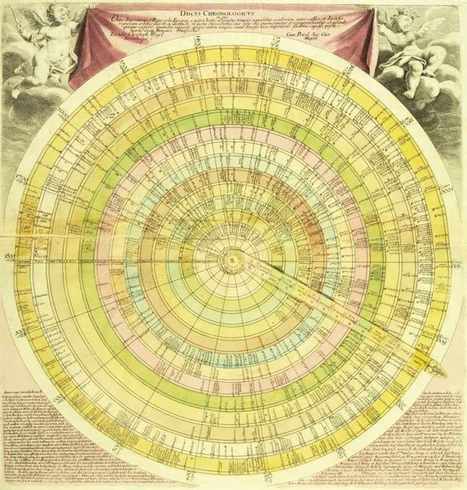
Selections from Daniel Rosenberg and Anthony Grafton’s captivating history of timelines, now in paperback—from time circles to time dragons, to a history of civilization drawn on a single piece of paper.
How do we spatially organize time to give it a visual representation that is somewhat intuitive? This fascinating gallery portrays various attempts throughout the centuries of how historians have mapped out their historical narratives.
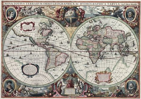
I typically would not link to a Wikipedia article, but this one is not only well crafted, but represents an academic collaborative work in its own right. This a fabulous cartographic gallery that explores the history of geographical thought through the ages (as archived in the earliest maps). Enjoy the maps, and even more, the intellectual context that this article provides for each of these images.
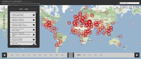
Browse the timeline of war and conflict across the globe.
This database of global wars and conflicts is searchable through space and time. You can drag and click both the map and timeline to locate particular battles and wars, and then read more information about that conflict. This resource would be a great one to show students and let them explore to find what they see as interesting. This site is brimming with potential.

olsen jay nelson's comment,
August 16, 2012 7:46 AM
This is just what I've been looking for, believe it or not:-)

Paul Rymsza's comment,
August 22, 2012 2:15 PM
the potential of this site is amazing between the interactive learning system and the correlation between the timeline and location. If the human geography class is anything like this i can't wait for it!
This is a most decidedly dated reference for pop culture, but a great movie for making explicit the idea that the way we speak is connected to where we've lived (also a good clip to show class differences as well as gender norms). The clip highlights many principles and patterns for understanding the geography of languages.
Tags: Language, class, gender, culture, historical, London, unit 3 culture and place.
Do you want some inspiration to create a visually stunning - yet fully optimized - data graphic? Well, let's go back about a 140 years... Handsome Atlas developed by Jonathan Soma of Brooklyn Brainery, provides a stunning new online interface to a large collection of beautiful data visualizations from the 19th century.
TR: Taking into account the age of these visualizations, one has to wonder if they intended them to be used by our generation in this way. I see potential for a "web 2.0" update of these charts to make them interactive . . .
Tags: infographic, historical, visualization, statistics.
|
TED Talks In this short talk, TED Fellow Sarah Parcak introduces the field of "space archeology" -- using satellite images to search for clues to the lost sites of past civilizations.
The uses of geospatial technologies is NOT limited to studying geography, but it is the bedrock of many research projects that involve spatial thinking (as demonstrated in this TED talk). Geographic principles and geographers can be very important members of interdisciplinary teams.
Tags: spatial, remote sensing, geospatial, TED, MiddleEast, historical.

Joshua Lefkowitz's curator insight,
January 15, 2014 11:13 PM
This sounds really intruging to me; I have heard of astroarchiology before in the aplication of finding undiscovered large objects (cities, towns sttlements) by using satellites to map deviations in teh earths surface accurately enough to distingush structures like a building foundation. I just find this sort of thing fascinating. I am still in awe that this dort of thing is possible.
Find great interactive world history games and activities for kids, listed chronologically by historical topic. Since so many geography teachers also teach history, this is a friendly link for the history teachers out there. Via Carla Saunders

Google Earth's Timeline, if you haven't discovered that feature will allow you to compare and contrast imagery from an area from the present 2010/11 to 1993-1995 images. Click the 'clock' button and a timeline that you can slide to the past appears. Nice historical possibilities with this option.

Matthew Rowland's curator insight,
April 18, 2013 12:35 AM
cool feature to google Earth... Too bad it can't go further back than 1995

The Spatial History Project at Stanford puts together some fantastic geovisualization that is an awesome site that allows you or your kids to spatial and temporally the diffusion of Nazi concentration camps. It has some clickable 'GIS-like' layers to help students contextualize the data and to make some important interdisciplinary connections. Originally spotted on http://ushistoryeducatorblog.blogspot.com/
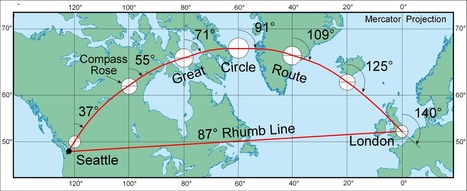
While the web mapping world still relies too much on the Mercator projection for my preference, it is a testament to the enduring impact that his ideas have had in literally shaping our World. When discussing map projections, this article has some valuable materials.
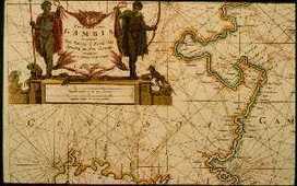
"The AFRITERRA Foundation is a non-profit Cartographic Library and Archive assembling and preserving the original rare maps of Africa in a definitive place for education and interpretation. This unique cartographic galleries links art, technology, and history." The Afriterra Foundation connects people to the land, history, heritage and legacy of Africa.
TED Talks A clay cylinder covered in Akkadian cuneiform script, damaged and broken, the Cyrus Cylinder is a powerful symbol of religious tolerance and multi-culturalism.
At first glance this TED Talk appears to be more about ancient history, archaeology and biblical studies that anything modern. Yet as Neil MacGregor, the Director of the British Museum continues his discussion of the Cyrus Cylinder (A clay cylinder covered in Akkadian cuneiform script), it becomes clear that this historical artifact is vital in understanding how modern states conceive of their heritage, cultural legacy and role within the Middle East today (such as Israel, Iraq, Iran and even the U.K.). As such the Cyrus Cylinder is a powerful symbol of religious tolerance and multi-culturalism and plays a role in shaping Middle Eastern cultural and political institutions.

Rebecca Farrea's curator insight,
November 8, 2013 9:16 AM
Neil MacGregor, the Director of the British Museum, explains Middle Eastern history using the Cyrus Cylinder. His first point in this TED talk is especially interesting because he explains that people age and perish and objects do the same, but objects such as this cylinder survive and are able to tell important stories of history for a much longer time than people normally can.
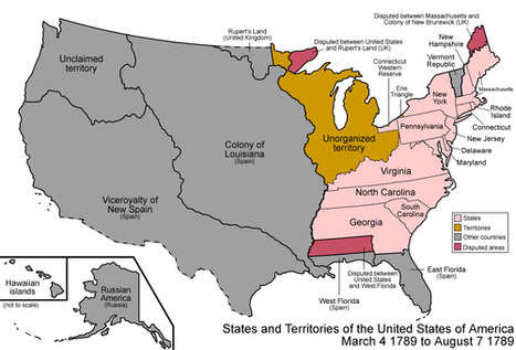
Amazing work from wikipedia, summarizing the evolution of the US formation, originally here: http://en.wikipedia.org/wiki/Territorial_evolution_of_the_United_States
Tags: USA, historical, visualization.
|


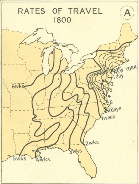
"This series of maps shows the great leaps and bounds that were made during the 19th century in transportation technology in the United States. This impacted population settlement, economic interactions and functionally made the great distances seem smaller. This is what many call the time-space compression; the friction of distance is diminished as communication and transportation technologies improve.
Questions to Ponder: When someone says they live "10 minutes away," what does that say about how we think about distance, transportation infrastructure and time? How is geography still relevant in a world where distance appears to becoming less of a factor? "
With the development of modern equipment useful in maneuvering around the world, the time it took those living in the 1800's has been reduced to getting anywhere around the world with time spanning from 30- 24hrs. This of course has been made possible due to the development of roads, better boating constructions and air travel.
Since 1800 the rate of travel has increased exponentially through the years. From the very beginning of travel, it would take close to a week just to get from the east coast to the middle of the United States. Through the use of railroads we have overcome the "time" factor and essentially eliminated it from playing a role in the way we travel. Today's advances in transportation has made seeing others much easier and most importantly it has developed a connected world that allows for transport of goods and services possible to such an extent that as citizens of the United states we are able to access almost anything we need from a day to day basis. A technology like this will continue to expand and grow to make the life of people that much easier.