Galapagos
2.9K views | +2 today
Follow
Galapagos
Information about the Galapagos Islands, Ecuador and South America
Curated by Dot MacKenzie
Your new post is loading...
Scooped by Dot MacKenzie
Scoop.it!

Map of America’s Hispanic population

Map of America’s Hispanic population | Galapagos | Scoop.it
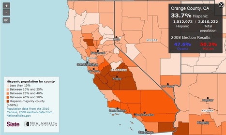
In the race to the White House, no ethnic group is more prized than Hispanics. President Obama ended deportations for some young undocumented immigrants, and the Romney campaign is vetting Sen.


This interactive map feature combines to interesting variables (at the county level): the percentage of the total population that is Hispanic, and the 2008 presidential election.  Analyze your local area and a few counties as well.  What connection exists between the two variables?  How come?  What are some exceptions to these general patterns?

No comment yet.
Scooped by Dot MacKenzie
Scoop.it!

Exclusive Economic Zones

Exclusive Economic Zones | Galapagos | Scoop.it

Today, a country’s marine economic area is defined by its Exclusive Economic Zone (EEZ), a 200-nautical mile-wide (370 km) strip of sea along the country’s national coast line (hi-res image). This regulation, which was installed by the ‘UN Convention on the Law of the Sea’ in 1982, grants a state special rights to exploit natural (such as oil) and marine (for instance fish) resources, including scientific research and energy production (wind-parks, for example).


Questions to ponder: how does this series of buffer zones around the Earth's land masses impact politics, the environment and local economies?  Where might the EEZs be more important to the success of a country/territory than other regions? 


Tags:  economic, environment, political, resources, water, sovereignty, coastal, environment depend, territoriality, states, conflict, unit 4 political.  

No comment yet.