Cultural Geography
31.9K views | +0 today
Follow
Cultural Geography
Historical, Cultural and Social Issues of place and space
Curated by Seth Dixon
Your new post is loading...
Scooped by Seth Dixon
Scoop.it!

Esri Story Map Treasure Hunt

Esri Story Map Treasure Hunt | Cultural Geography | Scoop.it

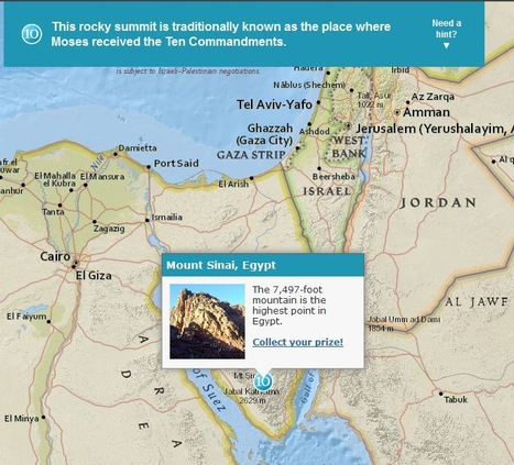
Although these were designed specifically for GIS day during Geography Awareness Week, these 2 excellent map-based treasure hunts from ESRI are great any time of year.  The answer to the question will only pop up in you are zoomed in the the right region (SHIFT + Make a box = Zoom to area).  These links will take you to the World Cities quiz and also to the Mountains quiz.

Seth Dixon's insight:

I love this geography, map-based quiz that let's people explore the world as they learn about some interesting places.  

Mark Hathaway's curator insight, September 9, 2015 2:52 PM

I enjoyed this exercise, it was fun and creative.

Douglas Vance's curator insight, January 18, 2018 7:00 PM

This is a brand new and to me, a unique way of exploring global geography by using trivia questions as a means to explore the world.

Kami Romeike's curator insight, April 8, 2018 5:29 PM

I love this geography, map-based quiz that let's people explore the world as they learn about some interesting places.  

Scooped by Seth Dixon
Scoop.it!

ORBIS-Historical Geography of Transportation

ORBIS-Historical Geography of Transportation | Cultural Geography | Scoop.it

This is a tremendous resources for understanding the historical geography of the Ancient Roman Empire and the transportation network.  Using ORBIS you can simulate travel logistics in the pre-modern era.  The differences between the fastest, cheapest and shortest routes between any two given locations can be very telling about the geographic factors impacting transportation.   

No comment yet.
Scooped by Seth Dixon
Scoop.it!

Stories Displayed on Maps

Stories Displayed on Maps | Cultural Geography | Scoop.it
On myHistro you can create advanced geolocated timelines that you can play as presentations. Pin your events, videos and photos to the map and share them with friends and family.


This new resource, myHistro, combines interactive maps with timelines to organize stories, journeys or historical events as the move over time and place.  By embedding photos, videos and links this creates an incredibly dynamic platform for telling historical and geographic stories.  By combining these features, this is a powerful tool to create customized resources for you students.  Pictured above is a sample timeline that shows the spatial and temporal journey of the Olympic torch for the 2012 Games.   

benjamin costello's curator insight, May 20, 2015 5:38 PM

Interesting concept but not totally fleshed out for use by historians... genealogists perhaps would have a better or easier time using this program. It is very interesting but it only allows for one movement, so rather than showing the history of a nation you can show the history of a family through its interactive timelines. Google maps is not always accurate as well. 

Scooped by Seth Dixon
Scoop.it!

Historypin

This is a video introduction to www.historypin.com which might just prove to be a very useful and important project.  It's historical geography powered by collaborative mapping that is infused with social media dynamics.  Backed by Google, they are geo-tagging old photos to recreate the historical geographies of all places and comparing them with current street view images.  You can search by topic, place or date...this has the potential to be very big.   

No comment yet.
Scooped by Seth Dixon
Scoop.it!

A History of Conflicts

A History of Conflicts | Cultural Geography | Scoop.it
Browse the timeline of war and conflict across the globe.


This database of global wars and conflicts is searchable through space and time.  You can drag and click both the map and timeline to locate particular battles and wars, and then read more information about that conflict.  This resource would be a great one to show students and let them explore to find what they see as interesting.  This site is brimming with potential.     

olsen jay nelson's comment, August 16, 2012 7:46 AM
This is just what I've been looking for, believe it or not:-)
Sakis Koukouvis's comment, August 16, 2012 8:06 AM
Oh... You are lucky ;-)
Paul Rymsza's comment, August 22, 2012 2:15 PM
the potential of this site is amazing between the interactive learning system and the correlation between the timeline and location. If the human geography class is anything like this i can't wait for it!
Scooped by Seth Dixon
Scoop.it!

Soda vs. Pop with Twitter

Soda vs. Pop with Twitter | Cultural Geography | Scoop.it
One of the great things about Twitter is that it’s a global conversation anyone can join anytime. Eavesdropping on the world, what what!


While many educators have been using http://popvssoda.com/ to show the linguistic regions in the United States, this is a similar map, with the added social media component.  To map out these regions, the cartographer used the word choice on geo-tagged tweets as the data source.  For another twitter, map, the following link shows which regions are most actively engaged on Twitter: http://www.huffingtonpost.com/2012/07/06/top-countries-on-twitter_n_1653915.html

What do these regions show us?  What types of regions are these?


Seth: This is a fun site! 

Courtney Burns's curator insight, September 14, 2013 10:35 PM
Twitter is something that is becoming widely used, and is something I usually check everyday. I never really thought of twitter beyond advertising and communicating. It is amazing the kind of data that can be extracted from peoples tweets. In the soda vs. pop argument I would say soda which makes sense since the data shows that people in the Northeast refer to it as soda. Twitter is so current that you can actually get some current and accurate data just from reading the hash tags in peoples tweets. It's amazing that such information can be extracted from all around the world.