

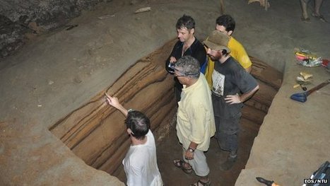

A cave on the northwestern coast of Sumatra holds a remarkable record of big tsunamis in the Indian Ocean. Scientists are using the site to help determine the frequency of catastrophes like the event of 26 December 2004.
Get Started for FREE
Sign up with Facebook Sign up with X
I don't have a Facebook or a X account


 Your new post is loading...
 Your new post is loading...
Your new post is loading...
A cave on the northwestern coast of Sumatra holds a remarkable record of big tsunamis in the Indian Ocean. Scientists are using the site to help determine the frequency of catastrophes like the event of 26 December 2004. 
No comment yet.
Sign up to comment
|


Sumatra's proximity to the Indo-Australia and Sunda tectonic plate boundary, and the giant earthquakes that occur there, means its shores are at risk of major inundations.Understanding how often these occur is important for policy and planning in the region. In the floor of the cave, encoded in the depositions of sand between layers of bat guano is a tsunami record providing detailed event histories from about 7,500 to 3,000 years ago that helps show the frequency of tsunamis in the region.