

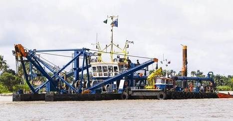

Dredging firms look ahead to more business, here and across the big pond. Along the way, Mother Nature and good business planning will both help.
Get Started for FREE
Sign up with Facebook Sign up with X
I don't have a Facebook or a X account


 Your new post is loading...
 Your new post is loading...
Your new post is loading...
Dredging firms look ahead to more business, here and across the big pond. Along the way, Mother Nature and good business planning will both help.
PIRatE Lab's insight:
We apparently like to dig up sediments.

No comment yet.
Sign up to comment
http://gallery.usgs.gov/videos/545 The 2011 Mississippi River flood was among the largest and most damaging to occur along this waterway in the past century....
PIRatE Lab's insight:
Jumpt to 1:55 if you want to skip the ad for USGS, jump to 6 minutes if you want to see some of the sediment cores themselves. The flood event dropped several cenitmeters of fresh sediment. We need more floods like this!!!
|
A new grant from the National Science Foundation (NSF) will help CSU Channel Islands (CSUCI) students study the effects of wildfire on the area’s ecosystem. The grant funds a collaborative research partnership between CI, UC Santa Barbara and University of Colorado Denver to systematically examine the impacts of wildfire on chaparral and watersheds. Linda O’Hirok, a lecturer in CSUCI’s Environmental Science & Resource Management program, is leading six students in the project this semester. A main focus of their investigation is Big Sycamore Canyon, which burned during the May 2013 Springs Fire that scorched 24,000 acres and threatened the CSUCI campus. They’re comparing the resilience of the recently-burned landscape with three similar sites in the region: a tributary of Matilija Creek that burned during the July 1985 Wheeler Fire, a tributary of Malibu Creek that burned in 1993, and an unburned tributary in Wildwood Canyon. “The growing danger of wildfires has increased our need to understand the way watersheds respond,” said O’Hirok. “By studying and measuring the post-fire runoff and erosion at four different sites in four different stages of recovery, we can piece together a compelling story of the short- and long-term effects of wildfire in chaparral environments. This could help us better predict dangers from erosion and flooding after wildfire and guide emergency planning.”
PIRatE Lab's insight:
Great work here by my colleage Linda O'Hiok. This highlights the value of long-term, often under- or non-funded, "unsexy" monitoring work. The decades-long monitoring of the geomorphology of this coastal stream is poised to help us better predict how and when coastal watershed will mobilize debris post burn...as soon as our winter starts...any day now...I hope!
|


