

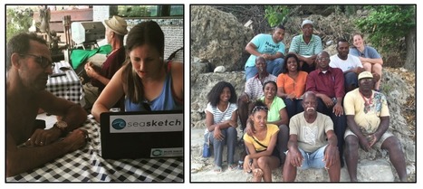

SeaSketch Supports Collaborative Planning for our Oceans
Get Started for FREE
Sign up with Facebook Sign up with X
I don't have a Facebook or a X account


 Your new post is loading...
 Your new post is loading...
Your new post is loading...
SeaSketch Supports Collaborative Planning for our Oceans
PIRatE Lab's insight:
Great example of modern Marine Spatial Planning wherein we pull together tools from various settings/populations. If you have not tried "SeaSketch" you should...even if you don't work in the marine world. This is a fantastic interface that grew out our our California MPA design efforts and has now grown beyond the horizon.
See also how SeaSketch is being used closer to home: http://www.seasketch.org/2016/05/16/Safe-Passage.html 
No comment yet.
Sign up to comment

The million-plus amateur cartographers who volunteer their time to plot roads, streets, and even shrubbery for Open Street Map were busier than ever this year. The beautiful map above, created by MapBox, shows how the database has grown since its inception in 2004. Hot pink areas are newly mapped, blue and green areas are older. (scroll down a screen length or two for the zoomable version within Mapbox's annual report). OSM's database of more than 21 million miles of roads and 78 million buildings, keeps finding new uses, such as helping first responders to disasters like this year's typhoon Haiyan in the Philippines.
PIRatE Lab's insight:
This open map project has finally gotten to the point where it seems generally useful for larger regional studies of coastal zones/road infrastructure.
It is great having both the formal google earth/apple maps datasets AND these more open-source datasets.

PIRatE Lab's curator insight,
December 28, 2013 11:56 PM
This open map project has finally gotten to the point where it seems generally useful for larger regional studies of coastal zones/road infrastructure.
It is great having both the formal google earth/apple maps datasets AND these more open-source datasets. |
The U.S. military is a primary user of ocean waters that needs dedicated offshore areas where it can train. But at the same time, the coastal ocean is playing host to a growing number of users, including shipping companies, fishermen, recreational boaters and energy producers. This new report describes how an ocean mapping system could help to ease conflict, while improving military readiness and safeguarding the marine environment.
PIRatE Lab's insight:
GIS/MSP for DoD and coastal resources.
|


