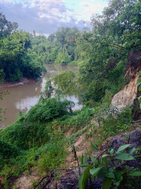
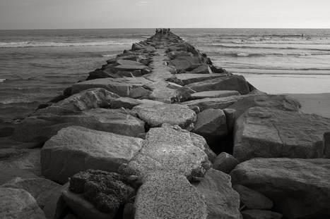
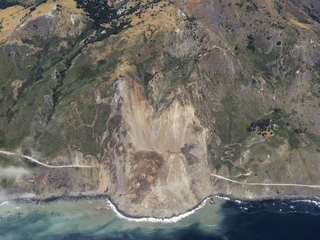
The section of highway collapsed Thursday afternoon about 15 miles south of Big Sur
Get Started for FREE
Sign up with Facebook Sign up with X
I don't have a Facebook or a X account


 Your new post is loading...
 Your new post is loading...
Your new post is loading...
The section of highway collapsed Thursday afternoon about 15 miles south of Big Sur
PIRatE Lab's insight:
See our previous studies from the Mud Creek Slide (south of where the current slide has happened):
https://youtu.be/ApO23Vhqbu4 https://youtu.be/2GUU6fLa-q8 
No comment yet.
Sign up to comment
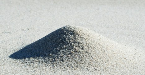
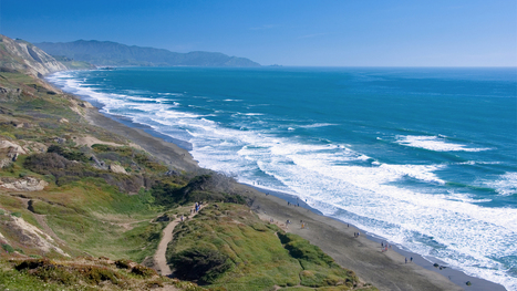
Growing up, I always imagined the beach to be a natural place. I think it’s safe to say that this sentiment may be pretty common among many beachgoers. It’s easy to think of the beach as being… Via kiki patsch
Protecting yourself when seconds count — what happens when the quake warning system goes off.
PIRatE Lab's insight:
Note: we have a beach warning, but no mountain, wetland, etc. warning. This speaks to the importance of beaches in both where we spend our time and the fact that these are iconic places.
The processor that makes your laptop or cell phone work was fabricated using quartz from this obscure Appalachian backwater.

From
qz

Construction on the US White House began in 1792. It has been almost continuously occupied by US presidents since 1800, barring a few years after the British set it on fire in 1814. But that doesn't mean that the present-day building is free of hazards—there are mice, cockroaches, and ants. And as of this pas
PIRatE Lab's insight:
Insert political joke here...
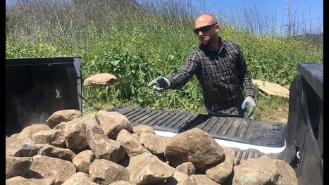
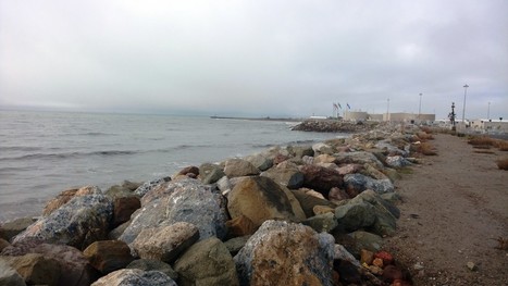
A pile of rocks and fill dirt from the Montecito disaster zone has become a popular spot for those looking for just the right stone for their property.
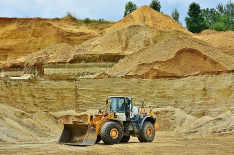
In 2010, nations mined about 11 billion tonnes of sand just for construction. Extraction rates were highest in the Asia-Pacific region, followed by Europe and North America. In the United States alone, production and use of construction sand and gravel was valued at US$8.9 billion in 2016, and production has increased by 24 percent in the past five years. Via EcoVadis
PIRatE Lab's insight:
We have seen our ow trail and travails for some of our high profile beach nourishment projects here in the Southern California Bight of late.
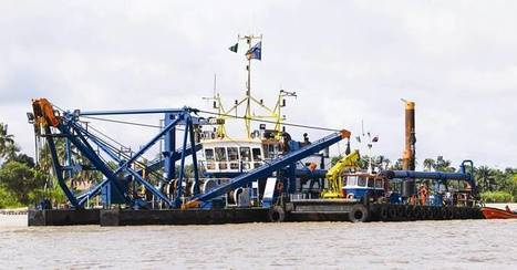
Dredging firms look ahead to more business, here and across the big pond. Along the way, Mother Nature and good business planning will both help.
PIRatE Lab's insight:
We apparently like to dig up sediments.
"Mont Saint-Michel emerges from the tides in Normandy, France, like an ancient village from a fairytale. The coastal town built on a massive granite rock cuts a dramatic silhouette against the sky, rising from disappearing marshes to a Gothic Abbey at its height. With a permanent population of around 50, this popular tourist destination has a history dating back to at least the Roman era. Fancy a tour before the tides roll in?"

Lauren Wilson's comment,
November 8, 2016 1:53 PM
This is a great addition to our lessons regarding erosion of cliffsides, in that it represents structures in place of an ever-evolving coastal environment. That such a feature can remain relatively unchanged by time and tides is a fascinating foothold in this study.
New 3-D images reveal just how bad erosion is along the Northern California coast.
PIRatE Lab's insight:
We are doing this with both visual and LIDAR sensing in our lab at CSU Channel Islands.

Joanna's comment,
November 4, 2016 4:52 PM
This article caught my interest because my research project focuses on the rate of erosion and the volume of sediment transport. In the past, geologists were limited to the use of surveying equipment to study erosion but this is a difficult task in places like Fort Funston of San Francisco, CA. This region is characterized by steep 160 ft. cliffs that have been eroding away significantly from exposure to waves, wind and precipitation. To get around this treacherous obstacle, USGS geologist Jonathan Warrick teamed up with Kenneth and Gabrielle Adelman. The pair have been taking aerial photos of the California coastline over several years. With the use of the historical photos, 3D maps of the beaches and cliffs have been created, showing areas of erosion and deposition. This is an awesome technique because it allows for the calculation of erosion trends, evaluation of processes that shape the coast and predictions for the impact storms will have in the future.
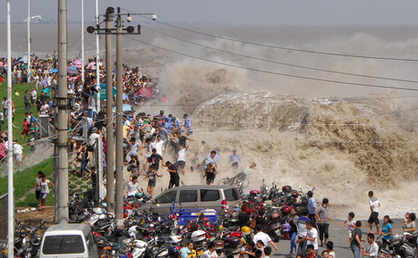
For hundreds of years, on the eighth month of the lunar calendar, people have gathered along the shores of China’s Qiantang River at the head of Hangzhou Bay to witness the waves of its famous bore tide. Higher-than-normal high tides push into the harbor, funneling into the river, causing a broad wave that can reach up to 30 feet high. If the waves surge over the banks, spectators can be swept up, pushed along walkways or down embankments. Below, I’ve gathered images from the past few years of the Qiantang bore tides.
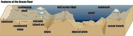
I'm joyfully studying for an earth science test this month to teach high school oceanography (one day)! I thought I'd share some fun questions here to test your knowledge. And, here's an image o
PIRatE Lab's insight:
Physical oceanography 101
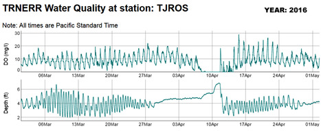
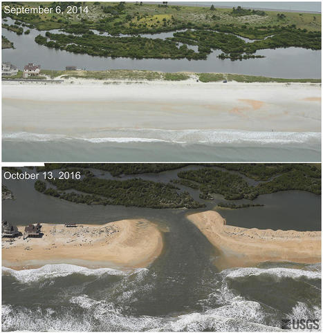
Some streets in Imperial Beach were flooded over the weekend with sewage-contaminated water after the mouth of the Tijuana River that opens into the ocean was blocked due to sand creating an overflowing, stagnant pool of water that killed some wildlife and endangered others.
PIRatE Lab's insight:
You may have heard that the Tijuana River Mouth closed to tidal circulation on around March 28th, 2016. The last time a closure happened was during the 1983 El Niño year. Storm surges and currents deposited sand from the north to block the mouth of the river again this year. Many of the other lagoons in the County close every year because their rivermouths are restricted by the coast highway and railroad.
In 2012, approximately 30 acres -three feet tall- of sand were deposited on the beaches in Imperial Beach north of the estuary as part of the SANDAG 2012 Regional Beach Sand Project. This material contributed to the mouth closure. According to our data logger near the end of Seacoast Drive in Imperial Beach (see below), the level of dissolved oxygen in the water, critical for fish to breathe, started to decrease around April 7th. That happened because no oxygenated ocean water was entering the marsh. Then the estuary became flooded with polluted water from runoff from the watershed. This water started to flood the south end of Seacoast Drive during the evening of April 10th. The river mouth was reopened on April 11th, using heavy equipment to move enough sand to let the perched water flow out to sea (see above). This closure resulted in poor water quality conditions as over 1000 acres -one foot tall- of sewage contaminated water flooded the estuary with runoff from the watershed. This caused the dissolved oxygen (DO) in the water to drop to zero (milligrams per liter) (see DO graph below) and a widespread die off of fishes and invertebrates in the estuary followed including several leopard and smoothhound sharks and shovel-nosed guitar fish. After only 19 days, however, the river mouth was blocked off again on April 30th (see the Depth graph leveling off) so Refuge staff is staying on top of it to attempt to keep it open.
|
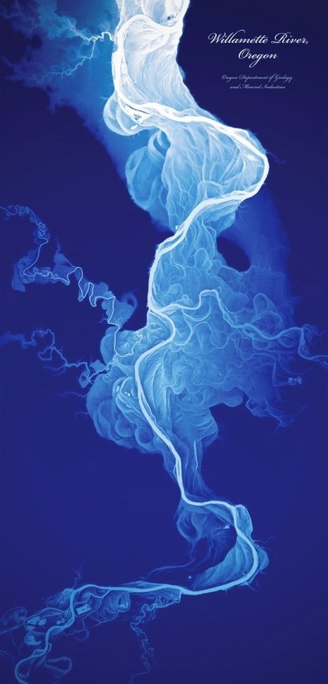
The poster by Daniel E. Coe shows the life-like historical flows of the Willamette River in Oregon. This lidar-derived digital elevation model of the Willamette River displays a 50-foot elevation r…
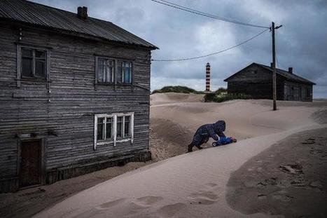
Shoyna, a fishing village in the frigid far north, is slowly vanishing under dunes that engulf entire houses. For children, home is now a giant sandbox. Adults have to “say goodbye to my high heels.”
In the wake of an especially destructive hurricane season, conservationists and urban planners are grappling with how to protect coastlines—and are increasingly looking to nature for inspiration.
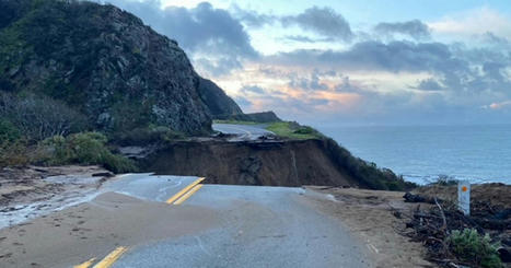
It's official. Caltrans said the road damaged by the biggest slide in California will reopen ahead of schedule.
PIRatE Lab's insight:
Share your insight
VCStar.com is the home page of Ventura County, California, with in-depth and updated local news, sports, things to do, investigative journalism and opinions.
Scientists searching for everything from oil and gas to copper and gold are adopting techniques used by companies such as…
Hurricane Matthew’s storm surge and waves overwashed about 15 percent of the sand dunes on Florida's Atlantic coast, 30 percent along Georgia’s coastline, and 42 percent of dunes on South Carolina’s sandy beaches as the powerful storm brushed past the Southeastern states October 6-9, according to USGS experts' preliminary review of USGS low-altitude before-and-after images along of the coast and NOAA photographs collected after the storm.
PIRatE Lab's insight:
A great example of pulsed loss of coastal elements: in this case sandy beach and dune communities. Additional imagery is available here: http://coastal.er.usgs.gov/hurricanes/matthew/photo-comparisons/florida.php See also stories in the Miami Herald: And NPR's Morning Edition:
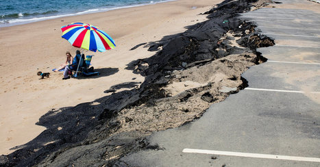
At Herring Cove Beach, facing an erosion problem as many other coastal areas are, a damaged parking lot is being replaced with one farther back.
PIRatE Lab's insight:
Retreating from the sea on the East Coast. This is a nice comparison to what we are trying (e.g. in Ventura) and hoping to try (e.g. Ormond Beach and Goleta) here in California.
|