

Newly licensed operators are getting to work.
Get Started for FREE
Sign up with Facebook Sign up with X
I don't have a Facebook or a X account


 Your new post is loading...
 Your new post is loading...
Your new post is loading...
PIRatE Lab's insight:
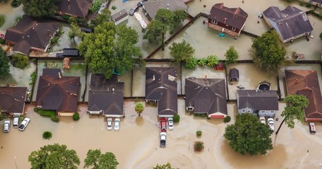
Anther example of using drones to census hurricane impacts in the wake of storms.

No comment yet.
Sign up to comment

The Federal Aviation Administration has given the University of Kentucky permission to research unmanned aerial systems or drones.
PIRatE Lab's insight:
Just to be clear this is about the University of Kentucky (not the United Kingdom as the original headline implied). Another groundbreaking permission to allow drones to fly where no one lives. Awesome for Kentucky, but this pattern of permitting things to happen where the real-world challenges of flying drones are minimal is not helping the rapid adoption of this technology.
To monitor whether whales are experiencing stress, researchers today have to do things that seem, paradoxically, kind of stressful. A team of Olin College students is developing a higher-tech, less obtrusive way to harvest these samples of whale mucus: a drone that hovers over the animals to collect samples. They chosen an evocative name for their robotic tool: Snot Bot.
PIRatE Lab's insight:
Snot Bot! Why didn't I think of that. Super cool.
Unmanned aerial vehicles (UAVs), known colloquially as drones, don’t offer just a safer way for scientists to observe their subjects; they’re often less costly, more efficient, and more precise than traditional approaches. As Junda can attest, biologists are still navigating the challenges and complexities of mixing wildlife and drones, working to improve maneuverability, autonomy, and endurance—and hitting regulatory hurdles. Learning curve aside, the technology holds incredible potential. “Drones are going to change the way that data is collected,” says Leanne Hanson, a U.S. Geological Survey biologist who has used them to count migrating Sandhill Cranes. Via Donald Rodriguez

Donald Rodriguez's curator insight,
August 15, 2014 6:51 PM
Quickly becoming the 21st century management tool
Los Angeles Police Department Chief Charlie Beck said Wednesday he would seek public opinion and assistance from privacy groups before using two unmanned aerial systems the department said it received from the Seattle Police Department.
PIRatE Lab's insight:
Powerful new tools need powerful standards and clear discussion of what is appropriate whenever they are unleashed upon our society. I hope these new aerial tools will be both effective and prescribed/limited. The potential for improving coastal management is amazing, but their potential downsides are great as well.
Landscape surveys and base map imaging using a DJI Phantom II Vision quadracopter in Big Sycamore Canyon State Park, CA. Ron, Gabriel, and Dylan. I do not ow... Via Dylan Ellis
PIRatE Lab's insight:
This UAS is quickly becoming the backbone of the entry-level aerial drone mappers. Here, one of my students filmed a demo run out at one of our post-fire burn monitoring sites in the coastal Santa Monica Mountains adjacent to our campus last Friday.

Dylan Ellis's curator insight,
February 22, 2014 3:01 PM
POSTED BY DYLAN ELLIS: Hey Gang,
I was with Ron Marotto, of the Ventura County Watershed Protection District, who is the Supervising Hydrographer of Watershed Resources and Technology Division, on 2/21/2014 in Sycamore Canyon testing a DJI Phantom II Quadracopter for base-map imaging of the new county rain gauge installed this past weekend. This is a revolutionary piece of equipment that has very wide policy implementation implications and cost saving incentives associated with it. This is Gabriel's (Ron's colleague in the video) personal quadcopter but the county is currently working on a proposal for a $15,000 DJI S800 that has 6 blades, a 50 pounds carrying capacity for field research and mapping. This bigger model can create entire DEM (digital elevation model) maps as well as spectral reluctant infrared maps just from visible light video camera flybys of watersheds and their waterways. Full longitudinal and cross-sectional data can be completed in an hour of fly time and computer data work. If you have ever surveyed a cross-section then you know this is a multi-day project. Policy implications are poised towards high cost savings associated with expedited mapping process. Ron said that a single airplane base-image run costs around $15,000, again for a single image. This means millions of dollars of savings in a single year alone for mapping and surveys of watersheds. When this technology is spread to different divisions and departments of the government then that figure could multiply into the billions. I hope you enjoy the theatricality.
-Dylan

"Everyone still thinks exploration is what research institutions or National Geographic gets to do, and that's just not the world we live in anymore." (RT @pdp7: Powered by #OpenHardware #BeagleBone Black & #Arduino DUE, OpenROV raised $1.3 million... Via F. Thunus, Kalani Kirk Hausman
PIRatE Lab's insight:
We are now experimenting with these ROVs in the context of both undergraduate education and coastal research/monitoring here at CSU Channel Islands.
The neat things here are the cheapness of the instrument and the open framework approach. Our next phase will involve building manipulator arms, etc. with 3D printers. Following along the open source nature of the project, we will eventually be posting/sharing all our designs/innovations. Both technical and pedagogical.
See also: http://beagleboard.org/blog/2013-11-12-project-spotlight-openrov/
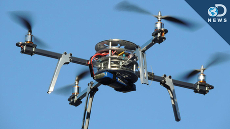
Forget helicopters: Quadrotors are where it's at! These four-bladed machines are revolutionizing everything from package delivery to search and rescue. Anthony explains how they work and why the U.S. Air Force has such a strong interest in them.
PIRatE Lab's insight:
I have seen more and more of these in disaster contexts, especially coastal ones. Mostly this has been folks flying their units up over a town/area to get a better perspective as to what has been happening. Several folks did this, for example, here after the 2013 Springs fire (some footage from which actually got heavy air play on local TV news).
|

The House passed a Federal Aviation Administration reauthorization bill Monday with a provision from Rep. Julia Brownley that would impose civil penalties for anyone using a drone to “knowingly or recklessly” interfere with wild fire suppression.
PIRatE Lab's insight:
This is my local congressional representative. While I like the base sentiment here, this whole issue of drone and wildfires is totally overhyped and a red herring. I don't think we need additional legislation on this matter at this point. Existing laws are enough to take care of and malicious intent.
While the recent drone crash in Yellowstone could prove to be devastating to Grand Prismatic Spring, it’s not the only item that has found its way into the park’s famed thermal features, such as these at Old Faithful. ©Travis J. Andrews Anyone who has visited Yellowstone National Park can attest to the beauty of Grand Prismatic Spring, a body of water that has a deep, brilliant blue color at its center and measures 370 feet in diameter. The pool is also recognized around the world for its other stunning tints, produced by the bright, multihued algae and bacteria around its edges. Since Yellowstone was declared America’s first national park in 1872, thermal features such as this have been protected for our enjoyment and that of future generations. But on August 2, 2014, a tourist from the Netherlands, Theodorus Van Vliet, crashed his drone into the spring. This incident occurred despite a ban that was instituted on June 20, 2014, on all UAVs (unmanned aerial vehicles) in all National
PIRatE Lab's insight:
The patchwork of policies and bans is getting hard to keep track of these days. Cities, states, federal lands: all are progressing at varying rates and making the use of this new technology challenging. Yahoos like this only make it harder for actual managers and researchers to gather data and evaluate new tools such as UAVs and ROVs, especially on public lands.
Drones can provide a low-impact, unobtrusive platform to observe marine mammals in the wild, but regulations haven't caught up.
PIRatE Lab's insight:
Yep.

Jorge Cruz Silva's curator insight,
September 11, 2014 3:01 PM
La legalidad de los drones no permite que varias iniciativas de importancia social y científica despeguen.
From
gizmodo

The Department of Commerce just lifted a ban on satellite images that showed features smaller than 20 inches. The nation's largest satellite imaging firm, Digital Globe, asked the government to lift the restrictions and can now sell images showing details as small as a foot. A few inches may seem slight, but this is actually a big deal.
PIRatE Lab's insight:
Here we go. I was just at the ESRI conference in San Diego and Digital Globe is pushing this in a big way.
We seem to be concerned about "drones," but there are a host of technologies that should be equally concerning. The cats of which are mostly already out of the bags.
Merry Christmas!
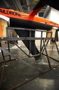
Scientists know so much about what’s happening above the surface of the water, but due to a lack of sensory equipment, they know comparatively little about what’s going on below. Most data for studying sharks, or any ocean phenomenon, is gathered via buoy (which are immobile), satellite (inexact, usually confined to surface measurement and not always in range) or scientists on a ship (time consuming and expensive). When predicting the weather on land, meteorologists can lean on countless weather stations to gather data and generate the forecast. This is where drones come in. Autonomous craft are reshaping the way scientists study the ocean and two local bay area companies, Liquid Robotics and upstart Saildrone, funded by the Marine Science and Technology Foundation (founded by Google chairman Eric Schmidt), have been making waves with their unmanned gliders and sailboats. Saildrone recently completed a voyage around Hawaii and back to the Bay Area with its autonomous sailboats. But now the group must prove its crafts can do more than simply get from point A to point B — like gather critical ocean data. Sensor for picking up acoustic transponders on great white sharks. “The next stage is to demonstrate that we can do real, valuable science,” says Saildrone lead researcher Richard Jenkins.
PIRatE Lab's insight:
Yet another way the autonomous vehicles can help us monitor remote areas at (literally) a fraction of the cost.
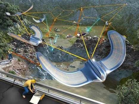
Swarms of drones could be the next frontier in emergency response Via Kalani Kirk Hausman

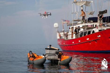
Scientists have deployed a set of drifting sensors and two drones outfitted with cameras to predict the path of oil through the ocean. Via AimForGood
PIRatE Lab's insight:
Yet another example of drone use in the coastal zone for effective research and monitoring.
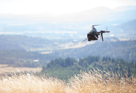
On a warm afternoon last summer in the hills west of Corvallis, three Oregon State University students went hiking in the McDonald-Dunn Forest when they became “lost.” A few scattered belongings — ...
PIRatE Lab's insight:
Here come UAS for a whole variety of applications.
|


