

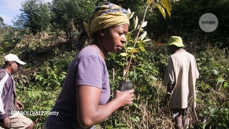
Restoration sites that would maximize biodiversity and climate benefits.
Get Started for FREE
Sign up with Facebook Sign up with X
I don't have a Facebook or a X account


 Your new post is loading...
 Your new post is loading...
Your new post is loading...
Restoration sites that would maximize biodiversity and climate benefits.
Grant Hassinger's insight:
The Scientific Article mentioned in this news paper https://doi.org/10.1038/s41586-020-2784-9 was an interesting read I especially liked how they discovered they could lower the cost 13 times by expecting some of the areas to require amounts of restoration.

No comment yet.
Sign up to comment
From
psmag

Historical sites across the globe are at risk due to rising sea levels, but without reliable data we can't even assess the full scope of the problem, let alone solve it.
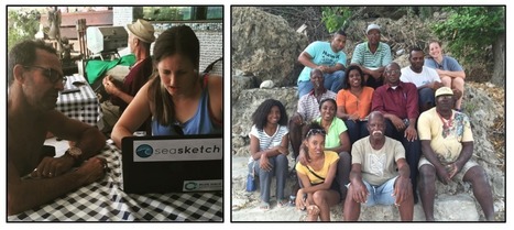
SeaSketch Supports Collaborative Planning for our Oceans
PIRatE Lab's insight:
Great example of modern Marine Spatial Planning wherein we pull together tools from various settings/populations. If you have not tried "SeaSketch" you should...even if you don't work in the marine world. This is a fantastic interface that grew out our our California MPA design efforts and has now grown beyond the horizon.
See also how SeaSketch is being used closer to home:
Bust your data out of its silo! Get more from data with Fusion Tables.
PIRatE Lab's insight:
This is a way to pull in data into Google Earth. This might be a nice way for folks without ArcGIS to get into spatial data exploration.
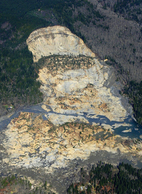
In recent decades the state allowed logging — with restrictions — on the plateau above the Snohomish County hillside that collapsed in last weekend’s deadly mudslide.
PIRatE Lab's insight:
There are several reasons for mudslides--some are purely a result of physical geography and others are related to land use patterns. This last week's mudslide in Washington state was a combination of the two and although this impacts one place (see on map), it is a good teaching moment to discuss the environmental impacts of land use patterns and resource extraction projects. As seen in this interactive, the river was cutting at the base of the hill, while loggers were clear-cutting at the top of the mountain. Trees help prevent erosion as the roots hold the soil in place--a critical piece to the puzzle in a very rainy climate. With $1 million worth of timber on the slope, logging companies persisted despite objections from the Department of Natural Resources and some restrictions (but in hindsight, those restrictions clearly were not enough).
View the impact in ArcGIS online: Before and After Swipe, LiDAR I and II, and Imagery.
Questions to Consider: Other than economic worth, what other ways are there to value and evaluate the environment? How could this landscape have been protected and managed better or was this mudslide inevitable?

Sally Egan's curator insight,
April 2, 2014 10:10 PM
Intersting relevance to Ecosystems at Risk and human activities which impact on ecosystems. 
Geofreak's curator insight,
April 3, 2014 1:39 PM
Mijnbouw en aardverschuivingen, een goede combinatie ...... 
El Futuro deWaukesha's curator insight,
April 18, 2014 12:03 AM
Working on an Inquiry of recent natural disasters with first grader.
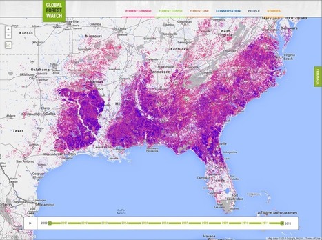
Global Forest Watch uses satellite imagery and other technologies to estimate forest usage, change, and tree cover (among other things). These estimates and their eventual actions used to be slow. Now they're near-real-time.
PIRatE Lab's insight:
This is about to change with the launch of Global Forest Watch—an online forest monitoring system created by the World Resources Institute, Google and a group of more than 40 partners. Global Forest Watch uses technologies including Google Earth Engine and Google Maps Engine to map the world’s forests with satellite imagery, detect changes in forest cover in near-real-time, and make this information freely available to anyone with Internet access.

Rooted In Hope's curator insight,
March 28, 2014 12:41 PM
Real-time data changing the face, and pace, of deforestation.
On 15 November 2013, the Directorate-General for Maritime Affairs and Fisheries (DG MARE) organised a workshop on Maritime Spatial Planning (MSP) and fisheries and aquaculture in Vilnius, Lithuania.
|
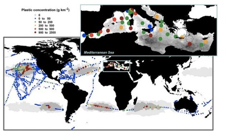
Advancements in satellite remote sensing techniques are paving the way toward the development of high resolution and temporal maps of marine microplastic distribution.
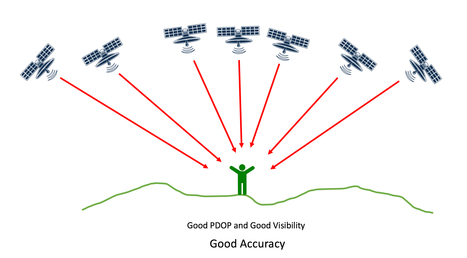
PDOP, HDOP and VDOP. What are these values and how do they work? This article explains these and the reasons why satellite technology works the way it does.
PIRatE Lab's insight:
Great explanation of PDOP (positional error) and some interesting results for some of our GPS receivers (Bad Elf, SXBlue, etc.)
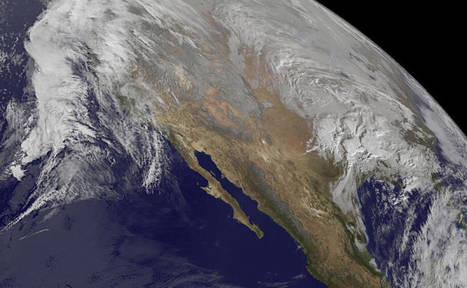
This fall, birds migrating south from the Arctic will find 7,000 acres of new, temporary wetland habitat for their stopovers in California.
PIRatE Lab's insight:
Good video on managing migratory water fowl.
From
gizmodo
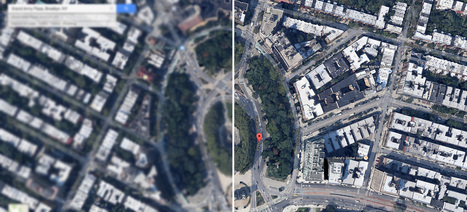
The Department of Commerce just lifted a ban on satellite images that showed features smaller than 20 inches. The nation's largest satellite imaging firm, Digital Globe, asked the government to lift the restrictions and can now sell images showing details as small as a foot. A few inches may seem slight, but this is actually a big deal.
PIRatE Lab's insight:
Here we go. I was just at the ESRI conference in San Diego and Digital Globe is pushing this in a big way.
We seem to be concerned about "drones," but there are a host of technologies that should be equally concerning. The cats of which are mostly already out of the bags.
Merry Christmas!
The U.S. military is a primary user of ocean waters that needs dedicated offshore areas where it can train. But at the same time, the coastal ocean is playing host to a growing number of users, including shipping companies, fishermen, recreational boaters and energy producers. This new report describes how an ocean mapping system could help to ease conflict, while improving military readiness and safeguarding the marine environment.
PIRatE Lab's insight:
GIS/MSP for DoD and coastal resources.
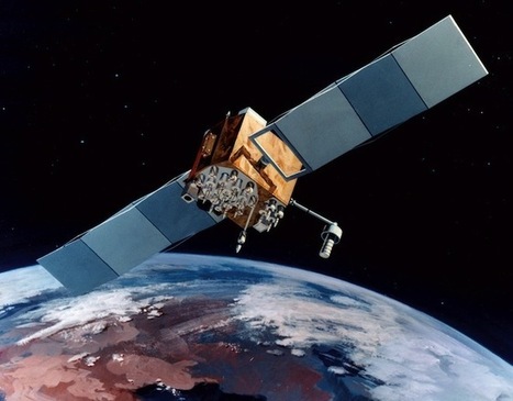
If there was ever a justification needed for space technology, it’s that it keeps people like me from constantly being lost. These days, my smart phone is much better than me at getting around thanks to a fleet of satellites ...
PIRatE Lab's insight:
Navigation at sea was revolutionized by GPS becoming available to all. I have many stories about folks who were proximate to war zones (e.g. during the first Gulf War) and their scrambled GPS signals suddenly got better/more accurate thanks to the military turning off the GPS fuzzing functions.
|


