
Focusing on the earliest periods of intensive monument building in prehistoric Scotland (3000–1000BC ), this study identifies how humans chose and made places that were important to them
Get Started for FREE
Sign up with Facebook Sign up with X
I don't have a Facebook or a X account


 Your new post is loading...
 Your new post is loading...
Your new post is loading...
Focusing on the earliest periods of intensive monument building in prehistoric Scotland (3000–1000BC ), this study identifies how humans chose and made places that were important to them 
No comment yet.
Sign up to comment
David Connolly's insight:
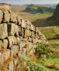
Newcastle University is bringing learners around the world to Hadrian’s Wall with its first ever free online course on the FutureLearn social learning platform. The six-week course, entitled ‘Hadrian’s Wall: life on the Roman frontier’, offers a comprehensive introduction to the most heavily fortified frontier in the Roman Empire, its people and their lives, and raises fascinating issues concerning colonisation, cultural transformation, immigration, integration and imperialism.
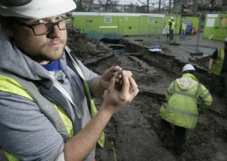
ARCHAEOLOGISTS have uncovered a slice of Georgian history on the former site of the Royal Infirmary hospital.
Pottery, bits of bottle, coins and buttons from the 18th century were found by workers at what is now Edinburgh University’s High School Yards.
A dig took place after contractors drafted in to lay utilities uncovered a series of outer walls from the old royal’s Surgical Hospital, which was built on the site in 1738. Among the highlights was a sixpenny piece dating from 1816 and the reign of George IV.
David Connolly's insight:
Great story, Jake is a lovely man from AOC Archaeology. Plus i am from Edinburgh. What is not to like!
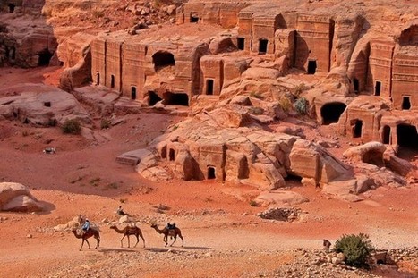
Turkey is an archaeologist's dream. Not only does it offer amazing Mesopotamian, Greek, Roman, Byzantium, and Ottoman ruins, it also offers yet un-explored sites for those interested in archaeology.
David Connolly's insight:
If you ever ever get a chance to go to Turkey! - Just go!
The use of information and communications technology (ICT) has revolutionized archaeological mapping, image recording, and analysis through tools such as GPS, GIS, and digital cameras (Evans and Daly 2006). Gidding et al. (2011) note that archaeologists have been slow to adopt integrated digital recording techniques, relying to an inordinate degree on paper-based recording systems to collect data on archaeological phenomena. Where archaeologists have utilized digital data, the resultant databases often can answer only very specific research questions (Gidding et al. 2011). That the challenges of using ICT field collection are becoming less of an issue is evidenced by the recent session at the 2012 Computer Applications and Quantitative Methods in Archaeology conference titled “Using tablet PCs to support field documentation
David Connolly's insight:
THis is going the be the way forward, but there will always always be a place for the pencil, tape and notebook ( well for now anyway! )

Martin Roseveare's comment,
January 30, 2013 11:46 AM
We've just built a proper integrated recording system for a project in Iraq (http://www.urarchaeology.org/). It does need proper ground-up design and a complete move away from the file-full-of-paper mindset to be properly useful

David Connolly's comment,
January 30, 2013 4:03 PM
Superb! Martin... you of course have made me jealous. This calls for a short article I think!

A 40-YEAR research project to map York’s historic past is finally nearing completion. A series of maps showing how the city developed from Roman times to the present day is set to be published, along with essays by leading academics. Dr Peter Addyman, chairman of York Civic Trust, had the idea of creating the cartographic study of the city’s development when he founded York Archaeological Trust in 1972.

What is curry? Today, the word describes a bewildering number of spicy vegetable and meat stews from places as far-flung as the Indian subcontinent, the South Pacific, and the Caribbean Islands.
But the original curry predates Europeans’ presence in India by about 4,000 years. Villagers living at the height of the Indus civilization used three key curry ingredients—ginger, garlic, and turmeric—in their cooking. This proto-curry, in fact, was eaten long before Arab, Chinese, Indian, and European traders plied the oceans in the past thousand years.
David Connolly's insight:
Harrapan Curry recipes to follow :)

The drive to build new roads, housing estates, industrial units and retail parks is having a devastating effect on some of Cornwall's most important historic sites, say campaigners.Plans to move the...
Cayo's Galen University is partnering with the University of North Carolina at Wilmington for a Public Archaeology Education Program.
"The partnership is a public education program geared towards young minds to enlighten and introduce them to the field of Archaeology and Anthropology and encourage them to consider those studies for their future as well as to educate them about the importance of studying our history and preserving archaeological sites for future generations. Dr. Scott Simmons of UNCW along with archaeology students Victor Cucul and Ismael Teul of Galen University served as “Ambassadors of the Past”, visiting the various schools on Ambergris Caye and talking about the history and culture of past civilizations, specifically the Maya, who were the original inhabitants of this entire region and whose impact and civilizations are still evident today." Via Best of Cayo, Sally McHugh
David Connolly's insight:
Partnership and education!
David Connolly's comment,
January 2, 2013 6:30 AM
Ah ... this is exactly the sort of archaeology I love the best!
A new, ultra-detailed climate record from a cave in Belize reveals Classic Maya civilization collapsed over centuries as rain dried up, disrupting agriculture and causing instability that led to wars and the crumbling of large cities. A final major drought after the political collapse of the Maya may be what kept the civilization from bouncing back. Via BelizeNet.com, Maya Research Program
A trove of fragments of fired clay found in a cave in Croatia suggest that humans of the ice age made ceramic art more regularly than believed.
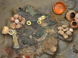
Archaeologists in Peru thought they had discovered something special when they uncovered the tomb of a pre-Inca priestess and eight other corpses in 2011. But an even bigger find was right beneath their feet.
Continuing their search for artifacts a year later, the team dug beneath the priestess, uncovering a basement tomb they believe was built by an ancient water cult and meant to flood.
|
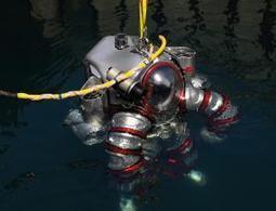
Like an underwater Iron Man, a diver will fly around the wreck of an ancient Greek ship later this year, looking to shed light on the Antikythera mechanism
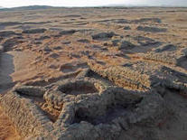
At least 35 small pyramids, along with graves, have been discovered clustered closely together at a site called Sedeinga in Sudan.
Discovered between 2009 and 2012, researchers are surprised at how densely the pyramids are concentrated.
They date back to a time when a kingdom named Kush flourished in Sudan. Kush shared a border with Egypt and, later on, the Roman Empire. The desire of the kingdom's people to build pyramids was apparently influenced by Egyptian funerary architecture.
Because it lasted for hundreds of years they built more, more, more pyramids and after centuries they started to fill all the spaces that were still available in the necropolis." [See Photos of the Newly Discovered Pyramids]
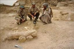
The discovery of a 3,550-year-old child’s sarcophagus near the southern Egyptian city of Luxor could shed light on a little-known period of Ancient Egypt, Jose Manuel Galan, the head of a Spanish team of archaeologists that made the find, told Efe on Wednesday.
David Connolly's insight:
Nice find

Fifty-six diagnostic sherds, dating to the Crusader period, were found in a pit. Most of them represent local Crusader types, with a few belonging to imported types. Via Ancient World Apps
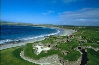
The University of the Highlands and Islands and Orkney's community archaeologist, Julie Gibson, said: "Scotland has the longest coastline in Europe and, as a maritime nation, much of our heritage relates to the sea. Around Orkney, more than one thousand archaeological sites are threatened or are being actively damaged.
David Connolly's insight:
Too true!
Discover UNESCO World Heritage Sites, which have been attacked during wars. We show the Sites before war, and where possible, what they looked after being attacked & how UNESCO has helped to resto...
David Connolly's insight:
A remarkable testimony

In China, ‘West’ means not Europe, nor America, but India, says Chinese archaeology student Ran Zhang, who is in the capital city to study the Chinese ceramic s...
A Real-Life Indiana Jones Who Converted To Islam And Discovered An Ancient City @Worldcrunch Worldcrunch - Great stories from the world's best news sources

Collapses highlight "critical" situation, but site is "absolutely safe for tourists." Via Leggo Tung Lei, Olivia Jane
The ancient city of Rhizon (modern Risan in Montenegro), was a strongly fortified Illyrian town which functioned as a successful trading centre, occupying a sheltered position in the Bay of Kotor on the Adriatic.
Lying in the innermost portion of the bay, Rhizan was protected from the interior by inaccessible limestone cliffs of the Orjen mountain, the highest range of eastern Adriatic, and through several narrow straits in the Bay of Kotor from the open sea.Image: Wikimedia commons
A stronghold of an Illyrian Queen
Ancient Rhizon was also a political centre for the Illyrians and it was here that Teuta, Queen of the Ardiaei tribe, established her capital. After negotiations broke down between Teuta and the Romans (who requested her to put and end to piracy in the Adriatic), the First Illyrian War broke out in 229 BC. However, the Illyrians could not withstand the might of Rome and the war was a short lived affair.
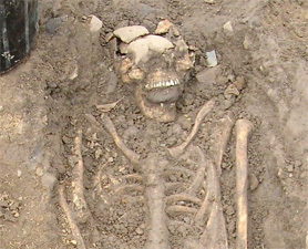
Two 8th-century skeletons with stones shoved in their mouths suggest that the people of the time thought so. Via Kyle Kunkel O'Connor
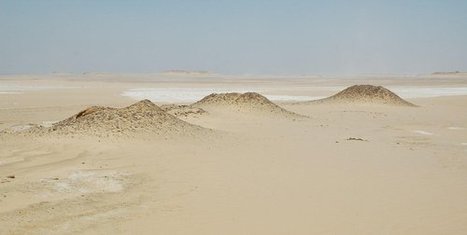
The place that went viral last month as the potential site of a mysterious Egyptian pyramid looks more like a series of mounds on the surface of Mars when you see it up close.
Based on the satellite imagery, Micol imained that the mounds represented eroded pyramids. The up-close pictures make the formations look more like piles of rocky rubble. The largest one appears to have the ruins of a square building or walls on its summit, but it'll take a full-blown excavation to fully date the site.
|