Your new post is loading...
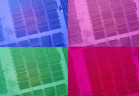
Researchers are trialling the use of drones to monitor coffee plant health in Thailand in a bid to prevent the spread of disease. Around 95 million cups of coffee are drunk a day in the UK alone, but the coffee plant is susceptible to a fungal disease known as coffee rust. This disease is devastating to the plant and can wipe out vast swathes of crops or even entire plantations. If a coffee plantation is hit by disease it can destroy an entire family's livelihood. In the lower-income regions where coffee is grown, farmers also tend not to use expensive fungicides that could prevent the disease. This is also because they want to grow coffee without using chemicals to secure organic certification. Now, a team led by Dr. Oliver Windram from the Department of Life Sciences at Imperial are hoping to be able to prevent the spread of coffee rust using drones, and have been testing this out in the coffee growing areas of Thailand. The idea is that if farmers can spot that disease has started to affect their crops, they can remove the affected plants to prevent it spreading further. This method would also allow them to control disease without chemical fungicides.
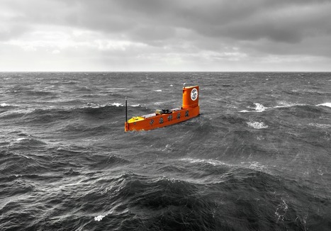
China has built and tested the world’s first robotic, partially submersible boat equipped with a robust system for launching sounding rockets — a technology used by weather scientists (called meteorologists) to better understand the atmosphere over our planet’s oceans. These tests were conducted in years 2017 + 2018 — and published in 2019. China’s experiment shows advanced capabilities: navigating hostile marine environments, robotically. And autonomously deploying rockets on-target to complete science missions — in places too dangerous or impassable for human teams to go. This combination of un-manned sea travel — plus a complex, remotely-managed rocket launch — is a clear demonstration of what’s to come. China’s successful test heralds a new era of at-a-distance robotics: with applications in defense, search + rescue, exploration, off-shore drilling, ocean fleet management, environmental protection, and a variety of command-and-control systems. The test is a non-trivial display of the power of automation. The robotic vessel carried extensive electronic instrumentation, requiring high levels of co-ordination + expertise by remote human operators. Since the crew isn’t physically there on-location: designers of enormous, computerized, mechanical systems of the future can train teams of engineers who won’t be limited by environmental hazard or distance. he un-manned ship and its rocket system. China’s ship is technically classified as an “un-manned semi-submersible vehicle.” It’s designed to: - sail directly into rough marine weather
- deploy a sounding rocket
- collect essential data on the atmosphere + ocean
The ship launched a key tool in weather research called sounding rockets. These rockets make brief flights through different layers of Earth’s atmosphere, carrying meteorological equipment as high as 5 miles above the ocean — higher than weather balloons. Scientific instruments carried by the rockets make real-time measurements of the sea surface temperature — plus profiles of pressure, humidity, wind speed + wind direction.
In modern times, farming's gone from humanity's top job to a sliver of the economy—a trend that continues today as fewer young people choose to farm. For every farmer under 35 there are 6 over 65, and a quarter of today's US farmers will retire by 2030. But we all still have to eat. One wonders: "If there are no new farmers, who will grow our food?"
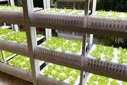
Robots, of course. One recent example? Japan's new automated indoor lettuce farm. Growing lettuce isn't the flashiest occupation, but it gets a little flashier when you do it with the press of a button.Japanese company Spread is expanding its indoor farm and more fully automating it. People will plant the seeds, but a robotic system takes it from there. Conveyor belts equipped with robot arms will water, trim, re-plant, and harvest crops. Sensors will monitor humidity, CO2, light, and temperature—automatically adjusting the indoor climate to make sure the lettuce is happy.
“The seeds will still be planted by humans, but every other step, from the transplanting of young seedlings to larger spaces as they grow to harvesting the lettuces, will be done automatically,” according to JJ Price, Spread’s global marketing manager. Compared to their current indoor farm, Spread's new facility aims to reduce energy costs by a third with LEDs. Automation will reduce labor costs by half, and by recycling 98% of their water, Spread says their pesticide-free lettuce consumes 100 times less than conventionally grown lettuce. Once operational next year, the farm will more than double production from 21,000 heads of a lettuce a day to 50,000 a day, and they're aiming for half a million a day in five years. While indoor farms offer a more controlled setting, farm robots aren't limited to them.
Self-driving tractors have been in fields for years. A farmer usually has to be in the cab, but they can focus their attention elsewhere, doing business on a laptop for example. (And full autonomy is coming.) Other kinds of farm robots abound. Robot arms can prune plants or spot and pick ripe fruit. Autonomous drones can skim fields and monitor crop health from above. All this farm automation isn't new; it's the continuation of a long trend. Robots will take over some jobs from people, but fewer of us are choosing to farm too. If your focus is elsewhere, no problem, farm robots like these ones will make sure you still eat your greens.
At current rates, ice sheet loss will become the most significant contributor to global sea level rise during this century, yet there is still a lot that scientists don't know about the underlying causes. This is partly because Antarctica is such a difficult place to take measurements.
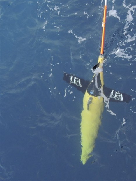
But now robotic underwater gliders are giving scientists new insight into why the Antarctic ice sheet is melting. An ice sheet is a huge layer of ice that sits on land. The two on the Earth today are found on Antarctica and Greenland, but in the last ice age there were also ice sheets on North America and northern Europe.
The Antarctic ice sheet spans more than 14 million square kilometers, which is roughly the same size as the US and Mexico put together. The ice sheet also spills out onto the surrounding ocean in the form of ice shelves.
The Intergovernmental Panel on Climate Change (IPCC) estimates that the Antarctic ice sheet is currently losing around 150 billion tonnes of ice per year. One of the main areas of ice loss is from the Antarctic Peninsula, shown in the red rectangle in the map below.
Japanese company Mitsubishi has unveiled a radiation-resistant robot aimed at cleaning up the crippled Fukushima nuclear power plant. Other firms, among them Hitachi and Toshiba, have also rolled out their own remote-controlled bots recently. The plant was damaged during the 2011 earthquake and tsunami. Robots are already working inside the plant, but none has been specifically designed for this kind of work. One UK expert said that working inside a nuclear reactor was "a challenge for robotics". Dubbed MEISTeR (Maintenance Equipment Integrated System of Telecontrol Robot), Mitsubishi's "tankbot" is about 1.3m (4ft) tall and has two arms, each able to hold loads of up to 15kg (33lb). The robot is equipped with various tools and has electronics hardened to withstand radiation. But Jeremy Pitt, deputy head of the Intelligent Systems and Networks Group at Imperial College London, said it was still a challenge for a remotely controlled machine to successfully replace humans in such harsh conditions.
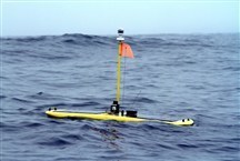
Now sharks, too, will have easy access to Wi-Fi hot spots. But the wireless signal-transmitting hot spots aren't for the sharks to use — they're part of a network of robots that are being deployed in the Pacific Ocean to gather data about where sharks, whales and other ocean predators swim. The robots will start gathering data this summer from predators that already have been tagged with acoustic devices. "Our goal is to use revolutionary technology that increases our capacity to observe our oceans," marine scientist Barbara Block, who organized the network from her laboratory at Stanford University, said in a statement. Block is sending to sea a combination of fixed buoys and solar-powered, self-propelling robots that look a bit like surfboards when they're in the water. (The robots, called Wave Gliders, set a Guinness world record in March for the longest distance traveled by unmanned vehicles.) Each buoy and robot will be able to detect any tagged animals that pass within 1,000 feet of it. The buoys and robots then will send their data to researchers on land in real time.
|
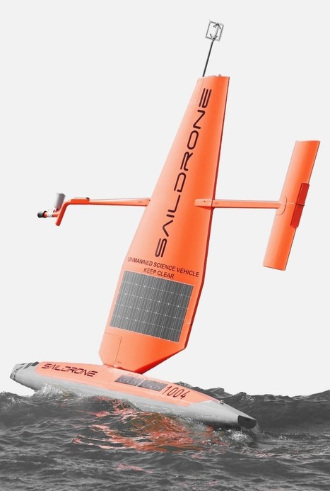
SailDrone makes wind powered + solar powered ocean drones to understand planetary systems affecting humanity. The company designs, manufactures, and operates their global fleet sail-drones — monitoring the state of the planet in real time. Their data sets can be used by commercial enterprise, research institutions, or private groups on specific missions. SailDrone is making world history by offering high resolution, ocean data collection at-scale. Their sail-drone is 20 feet long, 18 feet high above the water, weighs 600 pounds. It can operate indefinitely: the wind is propulsion that pushes it along, a solar power panel charges the batteries that run the on-board computers + communications equipment. The sail-drones navigate automatically using GPS, a system that uses space satellites to map the Earth. The craft is completely submersible and designed to handle the harsh effects of salt water. The sail-drones can autonomously travel 1,000s of miles: taking measurements of wind speed + wind direction, temperature, humidity, radiation, salinity, chlorphyll, pH level. Scientists in marine biology are using SailDrone’s fleet to monitor the Earth’s ecology + fisheries — tracking factors affecting food and climate for sea life. In the past, researchers relied on data collected by large ships that cost $10,000+ per day to operate. Also, large ships can only approach shallow water of at least 66 feet. But sail-drones can travel into waters close to shore — as shallow as 10 feet — and continue to take measurements. Another benefit is that sail-drones can stay afloat in rough weather, continuing to function — sailing the oceans without stopping for 12 months at a time. But big ships must avoid extreme storm weather or dock at shore — re-routing and interrupting science and commercial ocean missions.
It's one of those truisms that we know the shape of the surface of Mars and the Moon far better than we know our own planet. The reason for this is Earth's oceans: they cover 71% of the globe and are impenetrable to the satellite mapping techniques we use so capably on those other worlds. The scientific community has set itself the ambitious goal of correcting this anomaly. The aim is to have no feature on the ocean floor larger than 100m unmapped by 2030. It's a huge task when you consider at the moment the vast majority of the water-covered parts of Earth are known to a resolution no better than about a kilometer. Some big technological shifts will be required in the next 10 years to correct the picture. And that is really the raison d'être behind the Shell Ocean Discovery XPRIZE.
New drone technologies and innovation are reaching new heights withever increasing need to improve safety and maximize operational efficiency in underground mines. Keeping in view the risks and challenges usually faced during mining operations, new drone technology is on its way to replace labour-intensive methods of surveying, inspection and mapping. This is emerging as a new trend in the mining industry to capture 3D spatial data in hard-to-access underground areas in mines with an aim to remove much of the risk and increase safety on site. 3D mapping of large-scale sub-surface environments, such as stopes, drifts and ore passes will now become easy and cost effective. This heralds a new era for future underground mining.
In terms of safety and operational efficiency, underground mining has unique challenges, some of which can be addressed with technologies, such as 3D laser mapping and unmanned aerial vehicles commonly known as drones. Therefore there is naturally a push toward building such systems that are robust enough for hard underground mining environments as well as cost effective. The future is promising and the baseline technologies are already there that can be used to build high efficiency products. For example, we at Clickmox Solutions have developed a 3D mapping system based on SLAM (Simultaneous Localization And Mapping) algorithm, which can be installed on drones and vehicles. This system is capable of building 3D maps in real time without the need for GPS signal for positioning.
All such technologies are tied to the so called Internet-of-Things or IoT, which envisions a highly connected and intelligent system where each individual component talks to other components and makes decisions based on the need at that time. 3D scanning and mapping that facilitate automated collision avoidance and positioning are important parts of such a system. It is envisioned that soon off the shelf technologies based on IoT will make it convenient for miners to use autonomous vehicles and drones to increase safety and productivity.
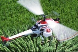
Drones continue their steady approach into the different aspects of our lives. But while controversy rages over drone devastation over foreign soil and prying surveillance over US soil, experts are beginning to point our attention to the real future of unmanned aerial vehicles: farming. Drones are expected to benefit farms both big and small – small farms can save money and resources through greater precision, big farms can map and characterize crop health and yield, for example, of large areas more easily. Such land monitoring was once performed on foot, with farmers seeing for themselves which areas need more water or fertilizer. With the advent of precision agriculture, remote sensing has already become vital to many large farm operations. Satellites and aircraft take pictures in infrared to determine water distribution and movement, as well as weed coverage. Thermal infrared sensors that measure heat can determine crop health from afar. Tractor booms are also being fitted with the multi-spectral cameras so that they can take measurements simultaneous with doing their jobs. But now drones can offer on demand images much more inexpensively. High performance GPS allows these aerial farmers to be controlled with precision and remain stable. The CropCam is an RC glider plane equipped with a Pentax digital camera. It’s operated manually or preprogrammed on the ground to collect aerial photos to provide imagery for agriculture, forestry, environmental and other uses. Another is Airrobot’s ARB100-B used in France for agricultural surveying. And far ahead of their American counterparts, over 2,400 Yamaha RMAX Unmanned Helicopters are already tending to farmland across Japan, South Korea and Australia (these top-of-the-line machines cost $125,000 each). And the RMAX can do more than just monitor, it can actually help with the farming. It’s equipped with a sprayer that can disperse granules, coated grains and fertilizers. The drone is smart enough to tell operators when airspeed is too high for optimal spread of material. And offering the farmer a rare opportunity to scale, up to six RMAXs can be operated simultaneously – tractors will need another gear just to keep up. As more farmers choose drones over tractors, aerial farming is expected to make a big impact on the unmanned aerial vehicle (UAV) market. A report, published earlier this month by the Association for Unmanned Vehicle Systems. International (AUVSI), estimates that 90 percent of potential markets for UAVs will be accounted for by public safety and precision agriculture. The FAA recently released a list of towns that have applied for UAV approval through October 2012 – there are 81 in all. The report predicts that widespread adoption of UAVs will inject $82 billion in economic activity and generate up to 100,000 new jobs between 2015 and 2025.
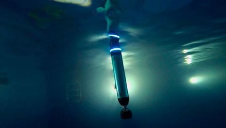
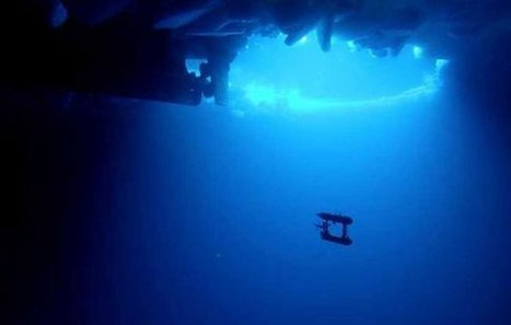
There has been no lack of underwater robots lately. They're proving the ability of autonomous underwater devices (AUVs) to run on solar power, they're monitoring harbors for pollution and they're working to repair damaged coral reefs. And now, they're allowing us to map Antarctic ice in 3D in order to see the total volume of ice in the area. Australian researchers are using an AUV to map the underside of Antarctic ice while helicopters are doing 3D mapping from above. This project will allow researchers to go beyond the satellite measurements of ice cover and give a more detailed picture of the ice and how it is changing. Project leader Guy Williams, from the Antarctic Climate and Ecosystems Cooperative Research Centre, said "In the past, we took drill-line measurements or observed ice thickness as we moved through [the ice] on a ship, but with the AUV, we can now use multi-beam sonar to measure an entire ice floe in unprecedented detail." The robot swims in a "lawnmower" grid pattern about 65 feet below the ice. It scans the area with the multi-beam sonar and then stores the information in an onboard computer. When each survey is done, the data is converted into a 3-D map of that part of the ice. This new data will go a long way in helping us to better understand how the ice is reacting to a changing climate. "The thickness of sea ice is regarded amongst climate scientists as one of the crucial indicators of [climate] change," said researcher Jan Lieser in a statement. "When we know how the thickness of sea-ice cover is changing over time, we can estimate the influence of global climate change on the Antarctic environment."
|