


 Your new post is loading...

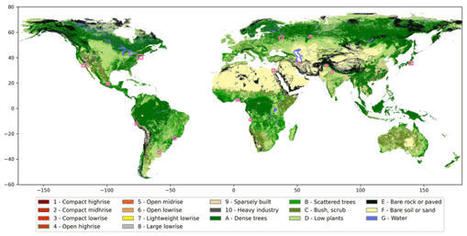

There is a scientific consensus on the need for spatially detailed information on urban landscapes at a global scale. These data can support a range of environmental services, since cities are places of intense resource consumption and waste generation and of concentrated infrastructure and human settlement exposed to multiple hazards of natural and anthropogenic origin. In the face of climate change, urban data are also required to explore future urbanization pathways and urban design strategies in order to lock in long-term resilience and sustainability, protecting cities from future decisions that could undermine their adaptability and mitigation role.


