


 Your new post is loading...

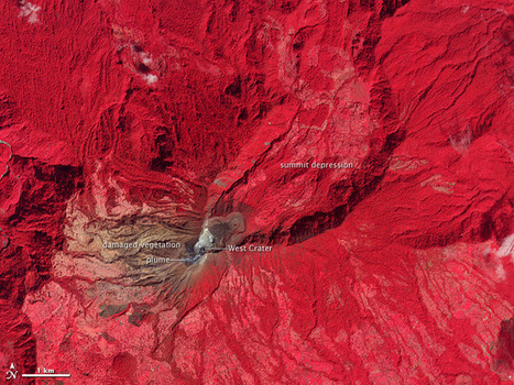

Emissions of gas and ash indicate an increase in activity at Costa Rica’s Turrialba volcano in January 2010.
A new vent opened this month on Turriabla, the easternmost of Costa Rica's active volacanoes. This false-color, near-infrared satellite image would be an effective teaching tool to discuss the importantce of geospatial technologies to monitor the Earth's surface.


This article reminds us of how fragile the earth’s crust can be. The rock can be ‘rotten’ when it is cooled prematurely due to rain, causing it to fracture more easily.
Using different teaching methods and technologies is a part of every day life. Figuring out new ways to teach students about observing and identifying whats happening in a photo is highly important. This geospatial photograph can be used in many ways. It can be used to note color differences, and realize that this volcano has emissions that can be seen in the picture erupting from it.
(Central America topic 9)
Having a volcano that looms behind your city suddenly come back to life is about as much of a wakeup call as anybody would want. Though in this case it was determined that a major eruption was not immanent, it raises the question as to weighing the risks of living in such areas. However, to me it seems that living at the base of Turriabla is not much more risky than living in other regions. Costa Ricans may have to deal with volcanoes, but so do those living around Mt. St. Helens, islands in the Pacific Ring of Fire, and even around Yellowstone. Aside from volcanoes, other environmental risks (floods, droughts, extreme temperatures, hurricanes, blizzards, landslides, tornadoes, wildfires, etc.) are other things just as worthy of being revered. So if you're safe from volcanoes, it's still likely you're more at risk from another form of nature's wrath.